Right after the 9/11 attacks in New York and Washington, DC there was an article in the Wall Street Journal about dirty bomb attacks. The idea was bad actors would get their hands on some radioactive material, and mix it with conventional explosives. This would cause panic and people to flee, potentially in large numbers. Having reliable ways to get messages out to other areas, such as Duluth, MN (120 miles away) was key. (500,000 people on the way in cars- prepare cots). My experience with the passing of voice relay messages was that it works but was not time critical.
I was talking to K0LAV who did some work with packet radio (AX.25) and decided on a unique frequency (145.67 MHz) back in the peak days (1980s) of AX.25 and BBS systems. BBS to BBS mail forwarding worked, but bogged down with large file attachments. The pounding away for hours of a large file attachment on a 1200bps radio link made a strong impression on me.
I put up station on 145.670 MHz, using a Kantronics Terminal Node Controller (TNC). I heard a few stations nearby and a mystery one, MNCCC7. After some digging around, MNCCC7 was from Askov, just south of Duluth. It was heard a few times a day, most days at my modest home station. An idea was born- if we added more powerful, commercial grade nodes, say 30 miles apart we could build a wide area network that was semi reliable.
The idea took off and we ended up with a meeting with the Minnesota Department of Health. The big need – to reach remote, outstate public health offices. The MDH person was not impressed by our 1917 era Radiogram form by the way. To reach Brainerd we bought and still own a former AT&T microwave site in Little Falls, MN which was on a hill blocking packet signals from St Cloud to Brainerd. The MDH sent me to give a poster presentation with them at the Public Health Preparedness Summit in 2007 in Washington, DC. There was discussion of vaccine distribution, and we have a signed MOU.
We plan to keep it running as long as there is some usage. It uses commercial sites, unmodified Kantronics TNCs- (KPC-3s and KAMs) and radios with transmit timeout timers. We do not allow BBS to BBS traffic forwarding on 145.67, (it acts like a perfect denial of service attack- flooding of packets and cannot be shut off) but you can access a BBS. There is a more modest backup backbone on 145.01. We run a few 145.01 sites. Duluth has some 9600 bps activity on 446.125. We built a node or two for that technology. It uses more expensive and fussy radios.
We have some 145.67>145.01 dual port stations, such as MNWBL. There are possibly plans to add more VARA on the same nodes/routes/sites (145.07) and even mesh. The packet route to Rochester is done. A goal is a route to Fargo for flooding support. The MSP>Duluth and MSP>Brainerd routes are solid. There are regular discussions of a mesh route to Rochester to support the Mayo Clinic. We own the needed sites.
Questions about Wilmar should go to the St Cloud Radio Club.
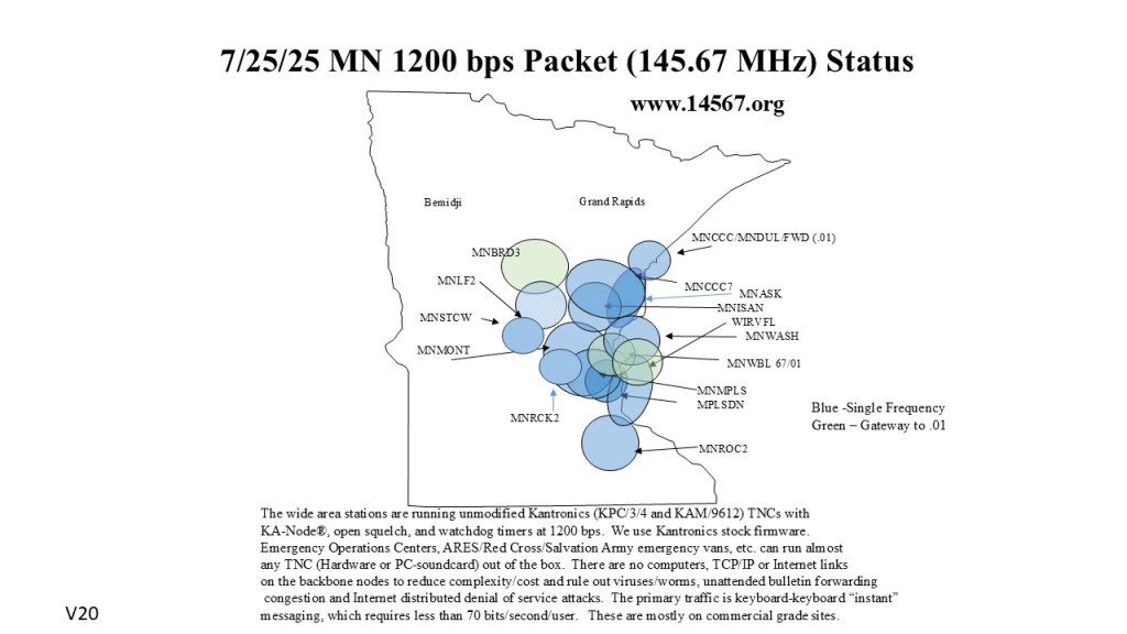

I think the “MNCLK” on that map should be “MNCLR”, in Clearwater
LikeLike
Clear Lake was sadly lost. I did not follow up with the City folks over the years. Good lesson. There was never a Clearwater site.
LikeLike
Thanks for getting MNRCK2 on line!
Now WILMAR users have options to explore.
LikeLike
Do you have any details about the new MNRCK2 node? Location and height?
73
Mike N0QBH
LikeLike
MNRCK2 is in the City of Rockford, at 150′ – facing SE. Not an ideal setup, but works.
LikeLike
Thanks for the info. Do you know of any packet map with details so that one might intelligently use the network, especially in the metro?
LikeLike
Core KANode list 3/2026.
MNCCC7 – Bit S of Duluth
MNRCK2- Rockford, MN
MNROCK- Rockford, MN K1LEO
MNWBL- Gew Lake, MN 140′ K0LAV-4
MNLF2 – SW of Little Falls, MN
STPONE- Downtown St Paul NY9D-8
MNMPLS – Downtown Minneapolis WD0HWT-10
MPLSDN- Downtown Minneapolis WD0HWT-4
MNBRD3- A few miles S of Brainerd
MNROC2 – North of Rochester, not at the airport. K0LAV-7
WIRVFL- Bit SE of River Falls, WI W0REA-12
MNWASH – Near Bayport, MN K0LAV-12
MNRUSH – Rush City, MN
N0YNT-7 – St. Paul, MN
MNCOLD – Cold Spring, MN WC0WLB-11
MNASK – Askov, MN W0ICR-5
WNWBTK- While Bear Lake, MN W0REA-4
MNISAN- Isanti, MN K0LAV-1
MNMONT Monticello, MN KC0WLB-4
KC0NPA-10 (Metro) WINLINK Gateway
LikeLike
Eric, that list in your reply to Mike would be a perfect companion to the map to get a better idea of whether a digipeater is close enough.
LikeLike
The idea for the backbone is you figure out in the Metro which site(s) give you best coverage and then you can node-hop after that. The design goal is we have a fleet of trailers and command trucks – wherever you are, pop up an antenna, and then find a gateway (there are some) send your traffic. The location of Winlink gateways etc. is helpful I think. The exact location of the core nodes is unpublished by design.
LikeLike
WILMAR has moved to VARA-FM we have a new packet site at Paynesville- MNSTCW KC0WLB-8
LikeLike
Two new sites MNMONT- Monticello (KC0WLB-4) and MNWBTK -(W0REA-4) White Bear are up
LikeLike
We have a powerful new node in Cold Spring that fixes everything. MNCOLD
LikeLike
MPLSDN is offline not sure why. MNCOLD also. MNWBTK and MNMPLS are decent backups. MNWBL and STPONE are not in great shape.
LikeLike